
Maine's largest wilderness area encompasses one of the nation's greatest state parks: Baxter. Including swaths of the Penobscot River, known for its rafting, landlocked salmon and brook trout, as well as the formidable Mt. Katahdin, the northern terminus of the Appalachian Trail and Maine's highest peak, Baxter State Park is an absolute gem and easily worth the drive.

Katahdin is 5277ft of weathered granite looming over the surrounding wilderness. Running along its ridge is a very narrow trail named the Knife Edge. We had plans to hike to Baxter Peak, the summit, via the Helon Taylor Trail and the Knife Edge from our campsite at Roaring Brook. Thunderstorms postponed our journey by a day, but breaks in the weather allowed us to hike around the nearby ponds and to fish to the resident brookies that called Roaring Brook their home.


The misting fog added some interesting elements to Stacy's watercolors as hundreds of tiny brook trout took surface insects around some grazing moose in mid pond.

Our lean-to was situated adjacent to Roaring Brook, and its gin-clear waters and plunge pools held some fine specimens of my favorite species of trout.


After a small, gorgeous brook trout on almost every cast for half an hour, the mosquitoes chased me off the water and back to camp to prepare for the next day's hike.

Cloudy skies greeted us in the morning as we hiked from camp at 6:00am. The Helon Taylor Trail is a long, slow ascent along a ridge of this carved-out mountain, and as we surpassed the tree line we entered a world of fog and mist.


If you stopped walking for even a moment, biting black flies swarmed. We kept up the pace until the fog hid us from them as effectively as it hid the view from us.

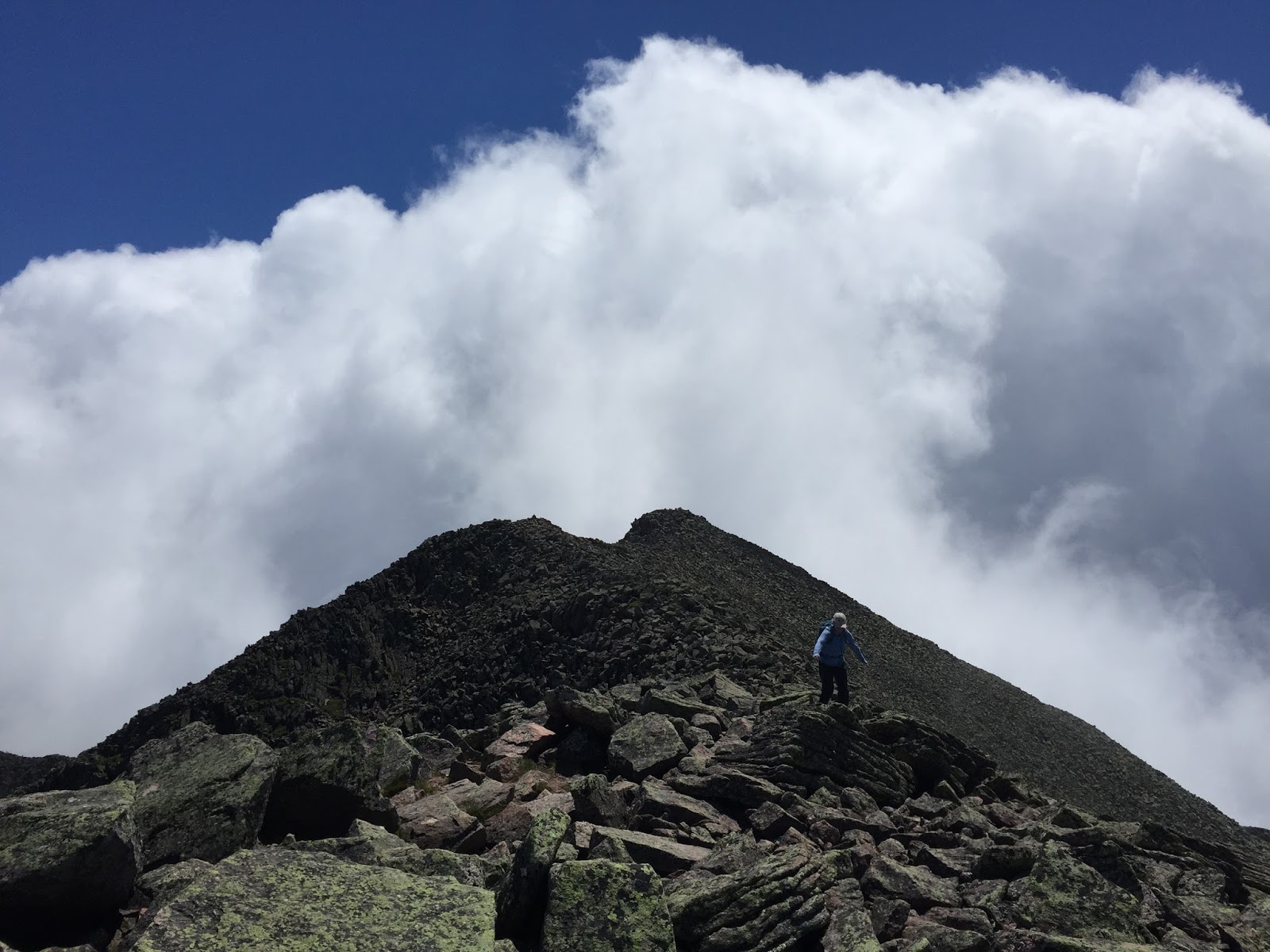
At Pamola we reached a junction with the Knife Edge. At times this trail is 3ft wide with a thousand foot drop on each side. We may have been better off without being able to see what laid to our immediate left and right for much of the trail.

Occasionally, the clouds parted into a bit of blue sky and afforded us a glimpse of what we were working along.


This view lasted approximately 15 seconds and I was fortunate enough to snap a photo of Stacy gently picking her way along the weathered granite ridge line. When the clouds parted for this view it took my breath away.


Breaks in the cloud cover became more frequent as we continued the careful walk along the Knife Edge. We could see deep into the cirque, an amphitheater carved out by glaciers and through which we would eventually need to descend.

Soon, we could see what lay before us, as well as what we had just completed. It was stunning, and unlike any other hike we've done.


Every rock was covered in an unreal palette of bright greens, red, purples and oranges from millions of years of lichen slowly colonizing this incredible landscape.


The summit gave us a few moments of rest as we thought about the prospect reaching this point after walking 2,189.1 miles from Georgia, instead of the 10 mile roundtrip we were in the middle of.
The descent was equally as arduous, and hard on the knees, but well worth it. If you ever find yourself thinking about Maine, make sure to include Katahdin in your plans.
2 comments:
Matt, those are some of the best photographs I've seen in a long while. The lake in the first picture is stunning.
Howard, those lakes are full of brook trout and moose, and some loons if you're lucky. Baxter State Park is simply stunning.
Post a Comment